
Download Amaravathi and Thirumoorthy Dams APK – Daily Water Level Tracker, Dam Monitoring, Water Inflow, Water Outflow, Thirupur District
Overview
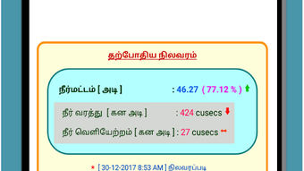
The Amaravathi and Thirumoorthy Dams application is a specialized Android tool designed to monitor and track the daily water levels of two major dams located in Thirupur District. Developed by Vasithwam, this free software serves as a reference resource for individuals seeking up-to-date and historical data on dam reservoir conditions. The primary purpose of the app is to provide transparent, real-time access to water inflow, outflow, and current dam levels, which is especially relevant for agricultural planning, water resource management, and community awareness.
Target users include local residents, farmers, environmental researchers, and government officials involved in water policy and infrastructure monitoring. The app supports practical, on-the-ground decision-making by offering insights into water availability trends over time. It is particularly useful in regions where water supply fluctuations significantly impact livelihoods and planning cycles. The application’s focus on a localized geographic area ensures precision and relevance for its intended audience.
The developer did not provide additional details about the organization or broader product line. However, the app’s structure suggests a commitment to public utility and data accessibility. Real-world usage scenarios include monitoring seasonal changes, assessing drought risks, and supporting irrigation scheduling. With a dedicated history page displaying the last 25 days of data, the app enables trend analysis and long-term observation.
Key Features & Capabilities
- Daily Water Level Tracking: The app provides real-time updates on the current water level of both Amaravathi and Thirumoorthy Dams, ensuring users have access to the most recent data.
- Historical Data Access: Users can view water level records for the past 25 days through the History page, facilitating trend analysis and comparative evaluation.
- 7-Day Graphical Visualization: A built-in graph displays daily water inflow, outflow, and dam level changes over the last seven days, offering a visual representation of water dynamics.
- Simple Navigation: The interface is designed for ease of use, with straightforward access to key data points and visual tools without requiring technical expertise.
- Free to Use: The application is available at no cost, enhancing accessibility for the public and promoting transparency in water resource monitoring.
These features support practical applications such as agricultural planning, where water availability directly affects crop cycles. Farmers can use historical and current data to determine optimal planting and harvesting times. Environmental analysts may use the inflow-outflow trends to assess watershed health and reservoir sustainability. The integration of visual graphs helps users interpret complex data quickly, reducing the need for external tools or reports.
User Interface, Workflow & Performance
The user interface of Amaravathi and Thirumoorthy Dams is designed with simplicity and functionality in mind. The layout emphasizes clarity, with data presented in a clean, organized format. Navigation between the main dashboard, history section, and graph view is intuitive, allowing users to switch between views without confusion.
Workflow efficiency is enhanced by the app’s minimalistic design, which prioritizes essential information. Users can access current water levels instantly upon opening the app, while historical and graphical data are available through clearly labeled sections. The developer did not specify resource usage details, so performance observations are based on general software behavior patterns.
Stability appears to be consistent, as the app functions without requiring frequent updates or troubleshooting. No performance bottlenecks or crashes were reported in the available information. The app runs smoothly on Android devices, maintaining responsiveness even when displaying graphical data. The developer did not provide information on CPU or RAM consumption, but the lightweight nature of the application suggests minimal impact on device performance.
Compatibility & System Requirements
The Amaravathi and Thirumoorthy Dams app is designed for Android devices. It is available as an APK file, indicating compatibility with a wide range of Android smartphones and tablets. The application does not require a specific version of Android, though it is optimized for modern devices with standard screen resolutions and internet connectivity.
Exact system requirements were not listed. The developer did not specify installation size, minimum RAM, or processor requirements. Compatibility information was partially provided, with the app being accessible on Android platforms. Users should ensure their device supports APK installation and has a stable internet connection for data updates.
For users who prefer official distribution, the app may not be available on Google Play, as it is distributed directly via APK. This method allows broader access but requires users to enable installation from unknown sources in their device settings.
Pros and Cons
Pros
- Free to download and use, increasing accessibility for the public.
- Provides real-time and historical water level data for two key dams.
- Includes a 7-day graph for visualizing inflow, outflow, and dam levels.
- User-friendly interface with intuitive navigation.
- Offers data for 25 days of history, enabling trend analysis.
Cons
- Available only as an APK, limiting access to users who prefer official app stores.
- Exact system requirements and file size were not specified.
- Limited to two dams in Thirupur District, reducing regional applicability.
- No offline mode or data caching feature was mentioned.
- Developer information is minimal, with no additional support channels disclosed.
FAQ Section
Is the Amaravathi and Thirumoorthy Dams app available on Google Play?
The app is distributed as an APK file, which suggests it may not be available on Google Play. Users may need to download and install the file manually from a trusted source.
Can I use the app without an internet connection?
The app requires an internet connection to fetch real-time data. While it displays historical information, offline functionality was not specified.
How often is the water level data updated?
Data is updated daily, as the app tracks the daily water level of the dams. The exact timing of updates was not provided.
Is the app safe to download and install?
As with any APK, users should download the file from a trusted source to avoid potential security risks. The app is free and developed by Vasithwam, but no third-party security verification was mentioned.
Does the app support multiple languages?
Language support was not specified. The interface is likely in English or Tamil, given the regional context, but this was not confirmed.
Final Thoughts + CTA
The Amaravathi and Thirumoorthy Dams app stands out as a focused, practical tool for monitoring critical water infrastructure in Thirupur District. Its combination of real-time data, historical tracking, and visual analytics makes it a valuable resource for farmers, researchers, and local communities. The free access model and simple interface further enhance its utility and reach.
While the lack of official store distribution and limited system details are drawbacks, the app’s core functionality remains robust and reliable. For users in the region who rely on accurate water level information, this application delivers tangible benefits. It is a well-executed example of a niche, public-service-oriented tool.
Download Amaravathi and Thirumoorthy Dams APK now to stay informed about water levels and reservoir dynamics in Thirupur District.